From Disagreement To Discovery: The Impact Of Early Martian Cartographers

Welcome to your ultimate source for breaking news, trending updates, and in-depth stories from around the world. Whether it's politics, technology, entertainment, sports, or lifestyle, we bring you real-time updates that keep you informed and ahead of the curve.
Our team works tirelessly to ensure you never miss a moment. From the latest developments in global events to the most talked-about topics on social media, our news platform is designed to deliver accurate and timely information, all in one place.
Stay in the know and join thousands of readers who trust us for reliable, up-to-date content. Explore our expertly curated articles and dive deeper into the stories that matter to you. Visit NewsOneSMADCSTDO now and be part of the conversation. Don't miss out on the headlines that shape our world!
Table of Contents
From Disagreement to Discovery: The Impact of Early Martian Cartographers
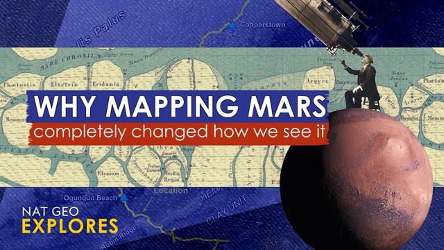
The red planet has captivated humanity for centuries, fueling countless scientific inquiries and sparking vibrant imaginations. Long before robotic rovers and high-resolution orbiters, our understanding of Mars was shaped by the painstaking work of early Martian cartographers. Their efforts, often hampered by limited technology and conflicting interpretations, ultimately laid the foundation for our modern understanding of this fascinating world. This article explores the significant, and often overlooked, impact of these pioneering scientists.
Early Challenges: Limited Data, Bold Interpretations
Early Martian cartography faced immense hurdles. The faint, blurry images captured by early telescopes yielded limited detail, leading to considerable disagreement among astronomers. Were those dark patches oceans? Were the lighter areas continents? The answers were far from clear. This lack of definitive data fostered a period of intense debate and competing theories, each reflected in the maps produced.
-
Giovanni Schiaparelli's Influence: The Italian astronomer Giovanni Schiaparelli's 1877 observations, though later proven inaccurate, profoundly impacted early Martian cartography. His description of canali, often mistranslated as "canals," ignited popular imagination and fueled speculation about Martian civilization. This fueled a surge in Martian mapmaking, even if some interpretations were wildly speculative.
-
Percival Lowell's Vision: Building on Schiaparelli's work, Percival Lowell, a wealthy American astronomer, produced highly detailed maps depicting a network of intricate canals, further bolstering the idea of a technologically advanced Martian society. While his interpretations were ultimately debunked, Lowell's meticulous mapping efforts, though flawed, undeniably advanced the field.
The Dawn of Photographic Mapping: A New Era
The advent of photography revolutionized Martian cartography. The ability to capture detailed images, albeit still grainy, allowed for more accurate representations of the planet's surface features. This ushered in a new era of mapmaking, gradually shifting from speculative interpretations towards more data-driven approaches.
-
The Mariner Missions: The Mariner 4, 6, and 7 missions in the 1960s and 70s provided the first close-up images of Mars, revealing a cratered and seemingly lifeless landscape, shattering many earlier assumptions. These missions provided crucial data for creating more accurate and scientifically grounded maps.
-
Viking Orbiters & Refinement of Martian Cartography: The Viking orbiters of the 1970s provided significantly higher resolution images, enabling the creation of vastly improved maps. These maps highlighted a wider range of Martian geological features, including volcanoes, canyons, and polar ice caps. This marked a significant transition from speculative maps to scientifically rigorous cartographic representations.
Legacy of Early Martian Cartographers: A Foundation for Discovery
While some early Martian maps were clearly based on flawed interpretations and limited data, they played a crucial role in the development of planetary science. They sparked scientific curiosity, fueled public interest in space exploration, and laid the groundwork for future, more accurate cartographic endeavors. Their work, even with its inaccuracies, highlights the vital role of early exploration and the iterative process of scientific discovery.
The evolution of Martian cartography underscores the dynamic nature of scientific understanding. What began as speculative renderings based on limited telescopic observations evolved into precise maps guided by high-resolution imagery from spacecraft. This journey reflects the collaborative and iterative nature of scientific progress, building upon earlier work, even if that work contains inaccuracies or biases. The legacy of these early pioneers serves as a reminder of the enduring human fascination with Mars and the vital role of observation, interpretation, and the constant refinement of knowledge in the pursuit of understanding our solar system.

Thank you for visiting our website, your trusted source for the latest updates and in-depth coverage on From Disagreement To Discovery: The Impact Of Early Martian Cartographers. We're committed to keeping you informed with timely and accurate information to meet your curiosity and needs.
If you have any questions, suggestions, or feedback, we'd love to hear from you. Your insights are valuable to us and help us improve to serve you better. Feel free to reach out through our contact page.
Don't forget to bookmark our website and check back regularly for the latest headlines and trending topics. See you next time, and thank you for being part of our growing community!
Featured Posts
-
 Frameworks Modular Gaming Pc Hands On Impressions And Future Potential
Feb 28, 2025
 -
 Metal Mario Races Into Hot Wheels This Summer
Feb 28, 2025
 -
 This Summers Must Have The Metal Mario Hot Wheels Car
Feb 28, 2025
 -
 Rtx 5000 Gpus The Impact Of Nvidias Phys X Retirement
Feb 28, 2025
 -
 Family Matters Exploring The Motivations Behind The Black Travel Boom
Feb 28, 2025
