Mapping Mars: How Cartographic Conflicts Fueled Our Fascination

Welcome to your ultimate source for breaking news, trending updates, and in-depth stories from around the world. Whether it's politics, technology, entertainment, sports, or lifestyle, we bring you real-time updates that keep you informed and ahead of the curve.
Our team works tirelessly to ensure you never miss a moment. From the latest developments in global events to the most talked-about topics on social media, our news platform is designed to deliver accurate and timely information, all in one place.
Stay in the know and join thousands of readers who trust us for reliable, up-to-date content. Explore our expertly curated articles and dive deeper into the stories that matter to you. Visit NewsOneSMADCSTDO now and be part of the conversation. Don't miss out on the headlines that shape our world!
Table of Contents
Mapping Mars: How Cartographic Conflicts Fueled Our Fascination
For centuries, Mars has captivated humanity. From ancient astronomers observing its ruddy glow to modern-day scientists meticulously analyzing its surface, the Red Planet has ignited our imaginations and fueled a relentless pursuit of knowledge. But the quest to understand Mars hasn't been a smooth journey; it's been punctuated by fascinating cartographic conflicts, disagreements over its features, and ultimately, a deeper understanding of both the planet and ourselves. These battles over the maps of Mars have unexpectedly amplified our fascination with this enigmatic world.
Early Interpretations and the "Canals" Controversy
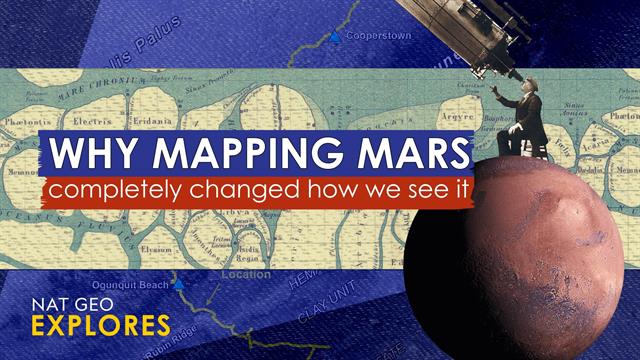
Early telescopic observations of Mars, hampered by limited technology, led to wildly different interpretations. The most famous controversy revolved around the so-called "Martian canals." In the late 19th and early 20th centuries, astronomers like Giovanni Schiaparelli and Percival Lowell reported observing a network of straight lines crisscrossing the Martian surface, interpreted as artificial canals built by a technologically advanced civilization. These observations, later proven to be optical illusions, nevertheless ignited the public imagination and fueled the burgeoning science fiction genre. This early "mapping" conflict – a clash between observation and interpretation – highlights the importance of rigorous scientific methodology and the inherent limitations of early technology.
The Space Race and the Rise of Accurate Cartography
The space race of the mid-20th century dramatically shifted our understanding of Mars. The launch of robotic missions, starting with Mariner 4 in 1965, provided the first close-up images of the planet's cratered surface, debunking the "canals" theory once and for all. This ushered in an era of unprecedented accuracy in Martian cartography.
- High-resolution imaging: Missions like the Mars Reconnaissance Orbiter (MRO) have provided incredibly detailed images, allowing scientists to create highly accurate maps, revealing geological features with stunning clarity.
- Data integration: Modern Martian cartography relies on integrating data from multiple sources, including orbital imagery, surface rovers, and even radar soundings, to create comprehensive three-dimensional models.
- Open-source data: The increasing availability of open-source data from various space agencies allows for collaborative mapping efforts, fostering international scientific cooperation.
Ongoing Cartographic Challenges and Future Explorations
Despite significant advancements, mapping Mars remains a complex challenge. The planet's diverse geology, including vast canyons, towering volcanoes, and polar ice caps, requires sophisticated mapping techniques. Furthermore, the ongoing discovery of subsurface water ice and potential signs of past life adds further layers of complexity to the cartographic puzzle.
- Subsurface mapping: Developing techniques to accurately map subsurface features, like water ice deposits and potential aquifers, is crucial for future human exploration.
- Dynamic surface: Mars is a geologically active planet, with processes like dust storms and glacial flows constantly reshaping its surface, making map updates essential.
- Improved resolution: The pursuit of even higher-resolution mapping continues, pushing the boundaries of our ability to understand the planet’s intricate details.
The Enduring Appeal of Martian Cartography
The history of mapping Mars is a testament to human curiosity and our persistent drive to explore the unknown. The cartographic conflicts, from the misinterpretations of early astronomers to the ongoing challenges of modern-day mapping, have not only shaped our understanding of the Red Planet but have also underscored the importance of scientific rigor, international collaboration, and the enduring power of human imagination. As we continue to explore Mars, the creation and refinement of its maps will remain an integral part of unraveling its mysteries and, in doing so, further ignite our fascination with this captivating world.

Thank you for visiting our website, your trusted source for the latest updates and in-depth coverage on Mapping Mars: How Cartographic Conflicts Fueled Our Fascination. We're committed to keeping you informed with timely and accurate information to meet your curiosity and needs.
If you have any questions, suggestions, or feedback, we'd love to hear from you. Your insights are valuable to us and help us improve to serve you better. Feel free to reach out through our contact page.
Don't forget to bookmark our website and check back regularly for the latest headlines and trending topics. See you next time, and thank you for being part of our growing community!
Featured Posts
-
 When Does American Idol Season 23 Air Your Complete Viewing Guide
May 05, 2025
 -
 Industry Topic Reimagined The Cameron Smotherman Perspective
May 05, 2025
 -
 Space X Starship Static Fire Test Results Larger Than Expected Flameout
May 05, 2025
 -
 Oasis Drops Song From Reunion Tour Over Inappropriate Lyrics By Disgraced Pedophile
May 05, 2025
 -
 Eu Cloud Data Decentralization Trumps Hyperscalers
May 05, 2025
