Mapping Mars: The History Of Cartographic Disputes And Their Impact On Public Imagination

Welcome to your ultimate source for breaking news, trending updates, and in-depth stories from around the world. Whether it's politics, technology, entertainment, sports, or lifestyle, we bring you real-time updates that keep you informed and ahead of the curve.
Our team works tirelessly to ensure you never miss a moment. From the latest developments in global events to the most talked-about topics on social media, our news platform is designed to deliver accurate and timely information, all in one place.
Stay in the know and join thousands of readers who trust us for reliable, up-to-date content. Explore our expertly curated articles and dive deeper into the stories that matter to you. Visit NewsOneSMADCSTDO now and be part of the conversation. Don't miss out on the headlines that shape our world!
Table of Contents
Mapping Mars: The History of Cartographic Disputes and Their Impact on Public Imagination
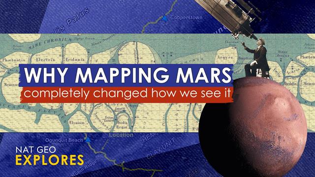
For centuries, humans have gazed at Mars, our celestial neighbor, fueling dreams of exploration and conquest. But before the rovers and orbiters, before the high-resolution images, there were maps – imperfect, often wildly inaccurate, and surprisingly contentious maps that shaped our collective understanding of the Red Planet. The history of Martian cartography is not just a scientific narrative; it's a fascinating tale of human ambition, scientific rivalry, and the powerful influence of visual representation on public imagination.
Early Speculation and the "Canals" Controversy
Early telescopic observations of Mars, starting in the 17th century, yielded limited detail. Nevertheless, rudimentary maps emerged, often reflecting the prevailing biases and technologies of the time. The late 19th and early 20th centuries witnessed the explosive "canals" controversy, a period dominated by the observations of Giovanni Schiaparelli and Percival Lowell. Schiaparelli's initial descriptions of canali (Italian for "channels"), were misinterpreted as artificial waterways, fueling Lowell's ambitious, albeit inaccurate, maps depicting a Mars teeming with advanced civilization. These maps, widely publicized and reproduced, captivated the public's imagination, igniting dreams of Martian contact and shaping science fiction for decades to come.
The Space Race and the Dawn of Accurate Mapping
The 20th century's space race dramatically altered our understanding of Mars. The first flybys and orbiters, starting with Mariner 4 in 1965, revolutionized Martian cartography. Suddenly, the romanticized canals vanished, replaced by a cratered, seemingly desolate landscape. This shift sparked a new kind of cartographic debate: the interpretation of geological features and the search for evidence of past water.
- Early robotic missions: Data from Mariner, Viking, and other early missions provided increasingly detailed images, leading to more accurate topographic maps and geological interpretations. However, even these early maps were subject to limitations in resolution and data availability.
- The rise of digital mapping: The advent of digital imaging and advanced computational techniques brought about a significant leap in accuracy and detail. Missions like Mars Global Surveyor and Mars Reconnaissance Orbiter produced unprecedentedly high-resolution maps, revealing canyons, volcanoes, and polar ice caps with stunning clarity. This data spurred new scientific debates, concerning the planet's geological history and the potential for past or present life.
Modern Martian Cartography and Public Perception
Today, Martian maps are constantly evolving, thanks to the ongoing work of orbiters, rovers, and landers. High-resolution imagery, three-dimensional models, and detailed geological analyses provide an ever-more comprehensive picture of the planet. This wealth of data fuels new scientific discoveries and inspires fresh waves of public fascination.
- Interactive maps and public engagement: The availability of online, interactive Martian maps allows the public to explore the planet's surface from the comfort of their homes, fostering a deeper understanding and appreciation for planetary science.
- The ongoing search for water and life: Current cartographic efforts remain focused on identifying regions with potential for past or present life, particularly areas that may have once harbored liquid water. The search for evidence of water continues to shape public perception and fuel exploration efforts.
The history of Martian cartography is a testament to the power of visual representation and its profound influence on scientific progress and public imagination. From the speculative canals of Lowell to the high-resolution images of modern missions, the evolving maps of Mars have consistently shaped our understanding of this enigmatic planet, inspiring scientific discovery and fueling the human dream of exploring the cosmos. The ongoing exploration and mapping of Mars promise even more exciting discoveries in the years to come.

Thank you for visiting our website, your trusted source for the latest updates and in-depth coverage on Mapping Mars: The History Of Cartographic Disputes And Their Impact On Public Imagination. We're committed to keeping you informed with timely and accurate information to meet your curiosity and needs.
If you have any questions, suggestions, or feedback, we'd love to hear from you. Your insights are valuable to us and help us improve to serve you better. Feel free to reach out through our contact page.
Don't forget to bookmark our website and check back regularly for the latest headlines and trending topics. See you next time, and thank you for being part of our growing community!
Featured Posts
-
 Lloyds Halifax Nationwide Uk Outdated Online Banking Causes Widespread Outages
Mar 04, 2025
 -
 March 2025 Altcoin Predictions 3 Tokens To Watch
Mar 04, 2025
 -
 Teslas Affordable Model Q Predictions For Casting Technologies And Production Costs
Mar 04, 2025
 -
 Analyzing The Impact Of Trumps Crypto Reserve On 3 Altcoins
Mar 04, 2025
 -
 Every Wordle Solution Alphabetical And Chronological List
Mar 04, 2025
